ESTEIO Engenharia e Aerolevantamentos S.A. Company Center

Contact details
Reinaldo Machado,1151
Curitiba-PR-80215-010
Brazil
+55 41 3271-600
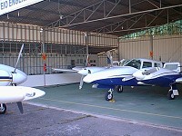
Navajo & Senneca aircraffts
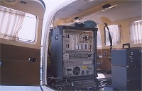
ALTM LiDAR System
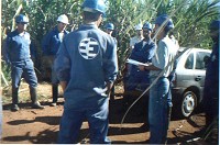
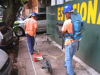
ESTEIO staff in a Pipeline survey
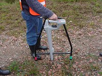
Pipeline Current Mapper Survey
Ground Profile Radar Survey
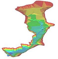
LiDAR DTM
Echo-Sounding
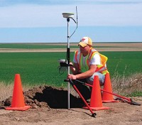
GPS Survey
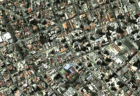
ADS Digital Image of Curitiba-PR
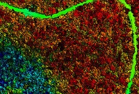
Rain Forest LiDAR Processing
INTRO
ESTEIO Engenharia e Aerolevantamentos S.A. is a Brazilian company which works in many engineering areas since 1969 and having as main activities the following: Highway, Railway and Airport Projects, Management and Supervision of Projects; Cartography; Photogrammetry; LiDAR; Digital Image Survey; Echo-sounding; Topography; Cadaster; Remote Sensing and GIS (Geographic Information Systems).
Always concerned on offering the best products to its customers and accompanying the technological development of these areas, ESTEIO counts with the best resources for execution of these services working with a highly qualified team and up to date equipment.
Besides the services itself, ESTEIO is capable to develop solutions for the most several problems related to its areas of performance. Its enterprising spirit is responsible for the introduction of many technologies in Brazil and South America, such as: GPS surveys; Orthophoto Mapping; Topographical surveys using total stations and data collectors; Aerial surveys with GPS (Airborne GPS); Airborne Laser Scanning (ALS); Geophysical surveys using GPR (Ground Penetrating Radar); DCVG & PCM (Pipeline Current Mapper); SBP (Sub Bottom Profiler).
ALS
Airborne Laser scanning is a technology that acquires digital elevation data of terrain with equivalent GPS accuracy but too much fast than it. A high-accuracy laser scans beneath the aircraft, producing a wide swath over which the distance to the ground is measured. In post-flight processing, the laser range, scan angle, GPS data and IRS data are combined to determine the position of a point on the Earth''s surface accurately.
Airborne Laser Scanning is an effective tool to collect Digital Elevation Models DEM that are used thoroughly in aerial photos rectification (orthophotos) and engineering studies. Their main applications include 3D Urban, Wireless Communications, Pipelines Emergency Route Planning, Power lines, Forestry Analysis and DTM (Digital Terrain Model).
GPR
ESTEIO has been worked with GPR equipment since 2000. It is considered the most sophisticated equipment for surveys and investigations of low depth. GPR (Ground Penetrating Radar) or GEORADAR is a geophysical method of investigation that basically consists in continuous emission of electromagnetic waves to the ground. Part of these waves is reflected on structures or objects in depth and the reflected sign are received by an antenna disposed in ground surface. After many years of development, GPR is considered the most sophisticated equipment for surveys and investigations of low depth. It is used in Geology, Engineering, Environment studies, highways and bridges surveys, archaeology and pipe detection.
PCM
Cathodic Protection (CP) is applied to buried steel pipelines to complement the protection provided by pipe coating. If the current becomes excessive or the cathodic protection ineffective, the pipeline must be surveyed to search for the major faults. Since 2001, ESTEIO has been using the Pipeline Current Mapper (PCM) as special equipment that has been specifically designed to perform this function.
The data collected by the PCM can be fed automatically to the GPS data logger so that positional information is recorded with PCM data. The data can be used to plot graphs of the PCM current. Faults can be clearly identified with their position and imported into a pipeline map.
FINAL
Always concerned on offering the best products to its customers and accompanying the technological development of these areas, ESTEIO counts with the best resources for execution of these services working with a highly qualified team and up to date equipment.
Latest Company News / Press Releases from ESTEIO Engenharia e Aerolevantamentos S.A.
Products & Services
- Consultancy Services (Aerospace)
- Engineering (Aerospace)
- Imaging / Image processing (Aerospace)
- Laser Technique, Power beams (Aerospace)
- Research and Development (Aerospace)
- Sensors / Signal processing (Aerospace)
- Surface treatment technologies (Aerospace)
Last update by Amauri Brandalize, Mon 24 Aug 2009